
 (Source: Wikimedia Commons)
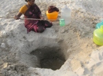
Pits made in the sand that provide sweet drinking water to the fishing community
Sweet drinking water found on the sandy beach flanked on both sides by the two oceans
The women collect this water, filtering it through a piece of cloth in their pots. They offer us some water. We are surprised to find that the water is very sweet and free of any salt!

Women from the fishing communities collecting drinking water from the pits made in the sand
We reach the end of the land where the two oceans meet and take in the view of the deep blue sea, gradually changing colours with the setting of the sun and the rising of the moon, wondering how such peace and tranquility can at times, also unleash such fury and destruction, but then, time goes on and heals all wounds!
References
1. Dhanushkodi: The Wikipedia, the Free Encyclopedia. Downloaded from the link http://en.wikipedia.org/wiki/Dhanushkodi on the 14th of March 2013


...............................................................................................
MY THOUGHTS/INSPIRATIONS /EXPIRATIONS
how there is non salty water available from wells just 10 feet =3 meter from sea in verssova beach?
Fresh water from a well in the sea at Rameswaram - Fate ...
Fresh water from a well in the sea at Rameswaram
In Rameswaram, an Island on the South east coast of India, there is a well some distance into the sea that provides water which is not salty and can be drunk. This is a holy place and according to Hindu mythology Lord Rama shot an arrow into the sea to get water to drink for his wife Sita. This is known as the Villundi Tīrtham well. How is it possible that you get non-salty water amid the sea water?
The Earth has Oceans which occur in “basins”. Continents, that is land we live on, is higher than the water level in the Oceans. (If you are keen for more, read about Isostasy.)
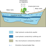
On land, groundwater occurs beneath the surface in what geologists call as Aquifers. Aquifers are geologic formations that can store and transmit water. Note that geologic formations are rock strata that have similar properties (for example rocks of a certain chemical and mineral nature is one such property). These have been deposited over millions of years (if you are interested read about stratigraphy, erosion, landforms, geologic time, etc).
-
- Aquifer (from wikipedia)

-
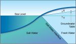
- Salt water-Freshwater interface

-
- Well water

-
- Water on the beach

-
- A well in the sea – at Rameswaram

Under some instances water gets collected from rain, rivers, and other sources and is stored underground in aquifers.
Aquifers constantly interact with other water sources, atmosphere, and is governed by forces such as pressure and gravity. The geologic formations too determine the aquifer’s nature – porosity, permeability, storage capacity, etc.
Groundwater near the coast interacts with the sea water too. The figure (source: Solinst) shows theoretically how groundwater exists. In reality though it is very complex.
Groundwater is recharged by rain and lakes or rivers. Thus Groundwater is not stagnant and flows. The flow is described by Darcy’s law which in simple terms means “groundwater flows depending on pressure and the length of the aquifer medium”. This pressure is the reason we are able to dig wells. This is often the capillary pressure.
Groundwater can be confined within strata and be under pressure. Or it may not have a confining layer and could be seen close to the surface.
The level to which groundwater can raise is the water table. Of course this is only for groundwater that is not confined by impervious or semi impervious strata. The potentiomentric surface is used to describe the water table level.
On the coasts, groundwater exists in “dynamic and often transient equilibrium” with sea water. Sea water is denser and filtrates into the ground beneath the sea and on to the land.
Groundwater should flow – discharge into the sea – as long as the water table level is at a higher pressure gradient. Sea water in turn will try to flow in and contaminate the fresh groundwater. There is a seawater-freshwater interface (not a sharp line!) that is transient and keeps changing with rainfall, river or lake discharge, tides and evaporation.
If humans pump out water from the coastal areas, sea water intrudes the fresher groundwater. The Gyben-Herzberg equation governs the fresher groundwater aquifer-sea water interface. For every feet of water on the surface, some 40 feet of groundwater exists below sea level.
So what does it have to do with this freshwater well in the sea? If
you dig a well in the sea you expect to get saline water. Yet, the well
provides drinkable water because of these possible scenarios:- the
freshwater-sea water interface extends far into the sea even beneath the
waves. Highly unlikely as the water table pressure would need to be
immensely high on the land!
– there is submarine discharge of groundwater from a confined aquifer
beneath the sea at this place. The strata confining the aquifer prevents
water from seeping out on the land side but there is a hidden interface
on the sea side.This is possible.
– maybe seawater has “transgressed” only on the surface and below the
surface is stopped from infiltering by impervious formations.
So this must be some kind of mix of these situations. The sea water here is pretty static – no waves in sight. Modeling coastal aquifers is a major headache. On Islands, the Fetter analytical solution applies better. I will not describe that here.
Usually, salt water intrusion into coastal aquifers is due to:
– lateral movement of salt water from the sea due to heavy water loss (withdrawals by humans) from the coastal aquifers
– “Saline zones” deep in the interface move up to cause “upconing” near coastal pumping wells
So is it possible? Yes. Fresh water is less denser than salt water and “floats” on salt water. This is important when you bore into the groundwater in islands. Rain water percolates into the ground and pushes the salt water beneath it. So you need to model the interface where freshwater and saltwater mix and take care not to disturb this by puncturing into sea water (when you drill).
Here is a citation that explains why this well gives freshwater:
“This natural movement of fresh water towards the sea prevents salt
water from entering freshwater coastal aquifers (Barlow, 2003).”
This natural movement of fresh water towards the sea prevents salt water
from entering freshwater coastal aquifers (Barlow, 2003).”
Similar examples exist at Cuba and the Gulf of Mexico.
There are 22 wells in the Rameswaram temple – on a shallow coastal aquifer (unconfined) and close to the sea. The dissolved solids vary in each.
So even if shooting the arrow part is not an acceptable theory, one must note the intelligence behind these wells. There was no technology and yet, this well was predicted to yield non-salty water.
.............................................................................................................Rameswaram
How To Reach Dhanushkodi
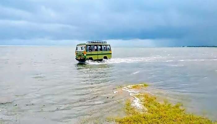

specially modified bus towards dhanushkodi


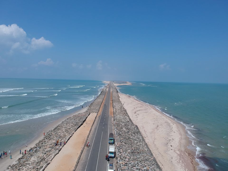
Dhanushkodi
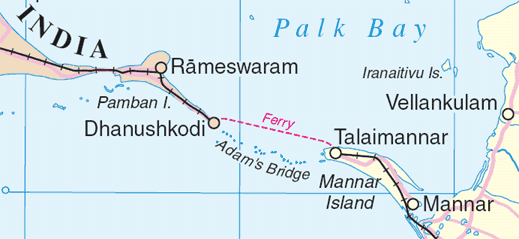
A map showing the location of Dhanushkodi island (Source: Wikimedia Commons)
Pits made in the sand that provide sweet drinking water to the fishing community
Sweet drinking water found on the sandy beach flanked on both sides by the two oceans
The women collect this water, filtering it through a piece of cloth in their pots. They offer us some water. We are surprised to find that the water is very sweet and free of any salt!
Women from the fishing communities collecting drinking water from the pits made in the sand
We reach the end of the land where the two oceans meet and take in the view of the deep blue sea, gradually changing colours with the setting of the sun and the rising of the moon, wondering how such peace and tranquility can at times, also unleash such fury and destruction, but then, time goes on and heals all wounds!
References
1. Dhanushkodi: The Wikipedia, the Free Encyclopedia. Downloaded from the link http://en.wikipedia.org/wiki/Dhanushkodi on the 14th of March 2013

A seasonal quality assessment on potability of fresh shallow aquifers along the Rameswaram–Dhanushkodi coastal tract, India


13 Citations
- Environmental ScienceJournal of Water Chemistry and Technology
- 2013
No comments:
Post a Comment